Discoveries in Mongolia

Roy Chapman Andrews (January 26, 1884 – March 11, 1960) was an American explorer, adventurer and naturalist who became the director of the American Museum of Natural History. He is primarily known for leading a series of expeditions through the fragmented China of the early 20th century into the Gobi Desert and Mongolia. The expeditions made important discoveries and brought the first-known fossil dinosaur eggs to the museum.
Infoquest Foundation has sent teams to Mongolia in 1996 and 2002. You can read the expedition "write ups" if you follow the links to the right.
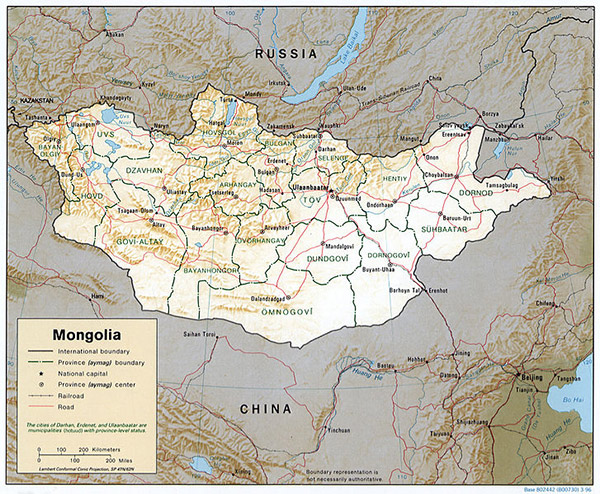
Present day geography and climateAt 1,564,116 km2 (603,909 sq mi),[24] Mongolia is the world's 19th-largest country (after Iran). It is significantly larger than the next-largest country, Peru. It mostly lies between latitudes 41° and 52°N (a small area is north of 52°), and longitudes 87° and 120°E.
The geography of Mongolia is varied, with the Gobi Desert to the south and with cold and mountainous regions to the north and west. Much of Mongolia consists of steppes. The highest point in Mongolia is the Khüiten Peak in the Tavan bogd massif in the far west at 4,374 m (14,350 ft). The basin of the Uvs Lake, shared with Tuva Republic in Russia, is a natural World Heritage Site. Most of the country is hot in the summer and extremely cold in the winter, with January averages dropping as low as −30 °C (−22 °F).[25]
The country is also subject to occasional harsh climatic conditions known as zud. The annual average temperature in Ulan Bator is 0°C, making it the world's coldest capital city.[25] Mongolia is high, cold, and windy. It has an extreme continental climate with long, cold winters and short summers, during which most of its annual precipitation falls. The country averages 257 cloudless days a year, and it is usually at the center of a region of high atmospheric pressure. Precipitation is highest in the north (average of 200 to 350 millimeters (7.9 to 13.8 in) per year) and lowest in the south, which receives 100 to 200 millimeters (3.9 to 7.9 in) annually. The highest annual precipitation of 622.297mm occurred in the forests of Bulgan Province close to the border with Russia and the lowest of 41.735mm occurred in the Gobi Desert (period 1961-1990).[26] The sparsely populated far north of Bulgan Province averages 600mm in annual precipitation which means it receives more precipitation than Beijing (571.8mm) or Berlin (571mm).
The name "Gobi" is a Mongol term for a desert steppe, which usually refers to a category of arid rangeland with insufficient vegetation to support marmots but with enough to support camels. Mongols distinguish Gobi from desert proper, although the distinction is not always apparent to outsiders unfamiliar with the Mongolian landscape. Gobi rangelands are fragile and are easily destroyed by overgrazing, which results in expansion of the true desert, a stony waste where not even Bactrian camels can survive.

