Ancient Mojave River Watershed Studies
Pleistocene and Holocene inland lake systems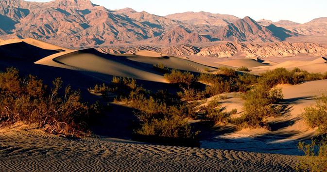
Divisions of Research and Discovery
The River watershed is very complex. We are concerned with the last 470,000 years before present. That is when the geologic forces created the northern flow of the river and began forming the watershed lakes. Our scope of study includes six branches of sciences; anthropology, archaeology, paleontology, geology, geography and hydrology.
Our goal for this site is to be a resource for students and advocates of desert studies and particularly the unique Mojave River basin. We are also going to create a K-8 educational section.
The Mojave River and it's Drainage
The Mojave River is the largest drainage system in the Mojave Desert. It has been nicknamed the "Upside-Down and Backwards" river. "Upside-Down" because the water flows primarily underground. "Backwards" because the water flows North, away from the Ocean, instead of South towards the Ocean as most rivers do.
The Mojave River currently flows North due to Geological events. The Mojave River system began developing as Westward-Flowing streams were blocked by the uplift of the Transverse Ranges along the greater San Andreas Fault.
The Transverse Ranges, the local San Bernardino Mountains, represent a complex of tectonic forces stemming from the interaction of the Pacific Plate and the North American Plate along the San Andreas Fault System. As Tectonic forces drove the Pacific Plate under the North American Plate, the North American Plate lifted upward creating the Transverse Ranges and a northern slope that redirected water runoff away from the Ocean and North to the Desert. With the San Andreas fault pushing the mountains up, slowing general drainage of the area, the Victorville Basin became a marshland for many years before the Mojave River reversed direction inland.
Western Region of the Watershed
The Mojave River originates in the Upper Watershed of the San Bernardino Mountains. This area comprises less than 5% of the total drainage basin area yet it accounts for more than 95% of the total basin precipitation. Its ephemeral waters, or episodic-lasting a short duration, gather from north of the mountains ridgeline and flow down a series of creeks and washes. The Mojave River's source is in the Eastern San Bernardino Mountains, one of the Transverse Ranges, above Hesperia / San Bernardino. The West Fork of the Mojave River flows from Lake Silverwood, formed by Cedar Springs Dam, which overflows in to the Mojave River Forks Reserve area. The East Fork of the Mojave River flows from Deep Creek. The East and West Forks join together at the Mojave River Confluence at the Mojave River Dam (Deep Creek Spillway).
Central Region of the Watershed
Downstream of the Deep Creek Dam, the Mojave River flows North and East,underground in most places, through Hesperia, Victorville, Apple Valley, and Barstow. The Mojave River does come above ground in certain areas where impermeable formations of rock forces water above ground. Usually, the river flow can be seen at the Upper Narrows between Victorville and Apple Valley, then downstream past Barstow at the Lower Narrows as the river begins its way through Afton Canyon. The river winds down the canyon and seeps back into the sand disappearing before it reaches Soda Lake near Baker.
Eastern Region of the Watershed
The Mojave River ends at the Mojave River Wash at the western edge of Mojave National Preserve. During heavy flows, the river reaches Soda Lake, near Baker and has reached Silver Lake in historic times. At the Mojave River’s peak during this last ice age, Lake Manix and Lake Mojave were large inland lakes. Dry Troy Lake and Coyote Lake are modern remnants of Lake Manix while Dry Silver Lake and Soda Lake are remnants of Lake Mojave. “The development of these lakes and other lakes in the region were progressive over time, with Manix Lake filling first, and Mojave Lake forming later when the Lake Manix filled to capacity and spilled westward, ultimately carving Afton Canyon during the last glacial maximum about 18,000 years ago” (Jefferson, 2003).
Mojave River Lakes
Harper Lake : Harper Lake is the furthest upstream and possibly the oldest lake of the Mojave River appearing 500,000 years ago.
Lake Manix : Lake Manix was the largest lake of the Mojave River system. It is said to have existed as far back as 470,000 years ago. Approximately 14,000 years ago, at a high water mark, it is thought that a seismic event caused a breach in the basin’shoreline which began the formation of Afton Canyon.
Troy Lake : Troy Lake is a remnant lake of Lake Manix. Some theorize that Troy Lake is an overflow point for the headwaters of the watershed flowing to Bristol Lake, then through a series of lakes to the Colorado River. Although no evidence of this possibility has been found to support this theory.
Coyote Lake : Coyote Lake may have also been a remnant lake of Lake Manix. It may have had flow directly in from the Mojave River at one time.
Afton Canyon : Two general theories may explain the formation of Afton Canyon. The first states that during a time of high water levels, the water poured over the top of the lakeshore and into the Lake Mojave basin to the east. This started a period of erosion several hundred to several thousand years long. The second theory is that a seismic event occurred which breached the canyon wall and lead to a rapid period of draining, possibly emptying Lake Manix in only a few days or weeks.
Mojave River Fan : The Mojave River Fan is a clastic wedge, possibly deposited during the initial carving of Afton Cayon.
Cronese Basin : In the past, the Mojave River fan may have diverted flow from the Mojave River into the Cronese lakes during periods of flooding.
Lake Mojave : Part of the Kelso Wash, consisting of the Soda Lake and Silver Lake.
Chronology of the Ancestral Mojave River
11 - 10 million years ago: The region sloped toward the Pacific Ocean
8 - 7.6 million years ago: Birth of ancestral Transverse Ranges (San Gabriel fault)
3.5 million years ago: San Gabriel Mountains rise blocking the slope to theocean and forming marshlands. Ancestral Deep Creek coming out of the San Bernardino Range begins to appear.
2.5 - 2 million years ago: Continued rise of the San Bernardino Range along the San Andreas fault reverse the regional drainage direction.
1.5 - 1 million years ago: The development of faults further to the north and east.
500 thousand years ago: Appearance of perennial lakes Harper and Manix ~ Our research starts here.
70 - 80 thousand years ago: Ancestral Mojave River develops as an incised channel with a course.
Mojave River Historical Notes
The Serrano Native Americans lived along the river for up to 8,000 years. The Indian trail, later the immigrants' Mojave Road, paralleled the river from Soda Lake to the Cajon Pass. Native Americans used this trade route where water could easily be found in route to the coast. Later, the Old Spanish Trail and Salt Lake Trail (Mormon Trail) joined up with the river and Mojave Road near the present-day location of Daggett.